Traffic message management for broadcasting
Our brief was to create an easy-to-use system for processing and editing traffic reports for the German broadcasting area. Nationwide traffic reports from the police (state reporting offices) were to be read in automatically and supplemented with information from the traffic departments of various broadcasters. This information in the form of listener calls is then evaluated by the editorial offices and entered into the system. Existing reports from the state reporting offices can be supplemented with listener information.
Our client
REGIOCAST is a radio company operating throughout Germany. Based in Leipzig, Kiel and Berlin, the company operates numerous analog and digital audio brands and holds around three dozen station and company participations: Radio stations, radio marketing companies and other service companies in the media sector.
Workshops
After some preliminary discussions, two workshops were arranged to explore the topics in greater depth. The aim was also getting to know each other and explore the working methods and skills of the team (123map/Regiocast).
Agile development
We then agreed on an agile approach for the joint project, based on SCRUM but with individual changes in some areas. Due in particular to the considerable research required into the data quality and standardization of the traffic data supplied, a first sprint lasting several months was planned, which is very unusual for SCRUM, in order to then move on to the detailed design and development. Many sprints later, after approx. 1.5 years, the first product version was ready for acceptance.
Required skills and technology
The following is a list of the (geo) resources we used to implement the project:
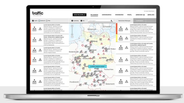
Traffic management system
Enrichment of the traffic information supplied by the state reporting offices with specific, standardized information based on geodata. This ensures that all reports can be selected with the selected filter criteria in subsequent processing steps.
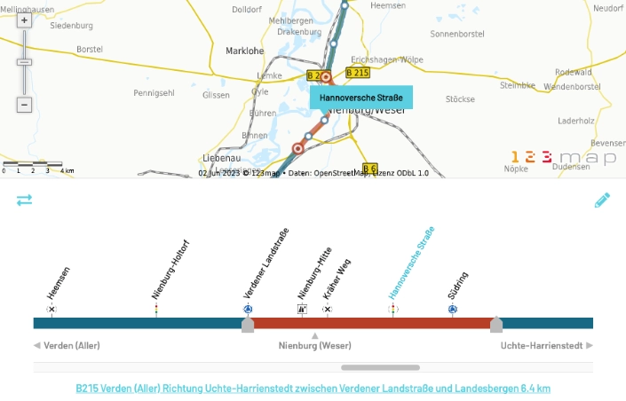
- Illustration of the annually published tables on the traffic network on OpenStreetMap maps. The BAST (Federal Highway Research Institute) publishes this information annually (TMC; Location Code List: LCL).
- Inheritance of existing geometry data from different versions of the Location Code List in order to be able to adapt to new versions with minimal effort.
- Creation of an editor for the Location Code List data. In the editor, new route sections are displayed on a map. There, the routes can be adjusted interactively if they are not correct. Changes are incorporated into all LCL versions available in the system.
- Connection of a routing server for the automated adaptation of route sections based on the road layout. Part of the editor functionality.
- Generation of road bands as a visual control element for traffic editors. All information contained in the Location Code List (exits, rest areas, intersections, etc.) is displayed two-dimensionally as a road strip with all exits, etc. The editor can generate route sections by simply clicking and dragging with the mouse.
- Generate text messages from road sections when dragging and clicking in the strip. All street names, superordinate route sections and the actual length of the event are pre-filled as text.
- Synchronization of road tape and map in a simultaneous view. The editor can set markers in both the map and the tape. What the editor marks can always be seen simultaneously in both the tape and the map. It is possible to zoom in independently in both the tape and the map. The other element is synchronized.
- Synchronous updating of traffic reports in map and list view every 20 seconds for all registered editors as well as real-time filtering of all displayed events in map and list with free text search (TypeAhead search).
- Development of a REST API to retrieve the processed traffic reports via an existing news portal
- Development of a comprehensive rights and role management system for customers and their users
- Integration of route sections from the LCL into the map for use in reverse geocoding. When entering new own messages, right-clicking on the map displays a dialog box with the most important roads etc. in the vicinity of the mouse click and can be called up.
Moderation front end
- Development of a template-based user interface for the presenters in the studios for the clear announcement of messages. The templates can be individually programmed by the customer and customized for the respective broadcaster. The possible individualization includes filter criteria, sorting, placeholder texts and conditional rules for placeholders.
- Individual presetting of the speaker speed to estimate the required announcement time depending on the amount of text
- Visual warning for traffic editors and moderators for urgent new messages also in the browser tab icon (with counter function)